Hellisheiði eystri


Hellisheiði eystri lies between Vopnafjörður and Fljótsdalshérað. When coming from Vopnafjörður, the route follows Hlíðarvegur (Road No. 917) around the bottom of the fjord and then along the southern coast of Vopnafjörður into Böðvarsdalur, a journey of about 20 km. From there, the road climbs steep slopes up to Hellisheiði, which spans about 14 km. When approaching from Fljótsdalshérað, you take a turn from Route 1 just north of the bridge over Jökulsá á Dal onto Road No. 917 and continue for about 33 km along Jökulsárhlíð until you reach Héraðsflói. The
road then ascends the heath following Hellisá, forming part of the route On the Edge.
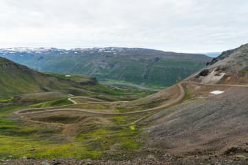
Crossing Hellisheiði is an adventure; the road is one of the steepest and highest mountain roads in Iceland, reaching up to about 665 meters. It is accessible to all vehicles in summer but is closed and not maintained during winter. Due to its high elevation, winter sets in early in autumn and spring arrives late. The vegetation on the heath reflects this, with plants like glacier buttercup and other alpine species, and the spring flowers often appear well into summer. Traffic on the heath is generally light, allowing travellers to enjoy the peace, natural beauty, and views at their leisure. On the Vopnafjörður side, just before reaching the Fagridalur slope, there is a hill called Fönn, where the snow rarely melts completely in summer. It is said that if the snow does fully melt, it predicts a very harsh winter.
On a clear day, the view from the eastern edge of the heath is spectacular, stretching from the vast ocean to the extensive lowlands and mountains of Fljótsdalshérað. By the coast is Héraðssandur, a black sand beach often lined with surf between the mountains. Inland from there is a wide, flat, and lush lowland. Beyond the flatlands, a majestic mountain range separates Hérað from the fjords, with the impressive Dyrfjöll mountains particularly notable. Further inland, you can see the valleys of Fljótsdalshérað and the highlands. The rivers Jökulsá á Dal and Lagarfljót have shaped the flatlands with glacial deposits and sands, constantly changing their courses and creating islands, as reflected in the many place names.
Kattárdalur and Fagridalur are significant valleys extending into the northern part of the cape between Vopnafjörður and Héraðsflói. Between them lies Dýjafjall, a bright green mountain covered in moss, easily visible from the road across the heath. Towards the tip of the cape is the centre of an ancient central volcano known as Fagradalseldstöð, which was active around 14.5 million years ago and is the oldest known central volcano in East Iceland. Only part of the volcano is visible above sea level, with the rest having been eroded and shaped by glaciers. The volcanic products are seen in various rock formations in the surrounding area, such as colourful rocks like light-coloured rhyolite. The road across Hellisheiði lies within the influence zone of this volcano, although the signs are more evident further out on the cape.
Fagridalur was long inhabited and considered a good resourceful farm with seals, driftwood, eider duck nesting, and fishing opportunities.A school also operated there. Fagridalur was abandoned in 1964.
Before motor roads, Hellisheiði was one of the routes between Fljótsdalshérað and Vopnafjörður. It was the trading route for residents of Jökulsárhlíð, who went to Vopnafjörður for commerce. There was also a postal route over Hellisheiði. In 1959, a trail was cleared over the heath. The route via Hellisheiði is about 40 km shorter than traveling via the main road through the Ring road (route 1) and route 85.
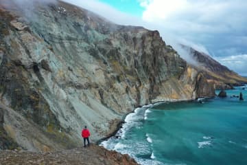
From Hellisheiði, there is a route to Þerribjarg and Múlahöfn. From the road over Hellisheiði a track leads northeast over Dýjafjall to Kattárdalur. This track is followed until a parking area and information sign in the Kattárdalur area. The hiking trail to Múlahöfn and Þerribjarg begins here. The trail is steep and quite challenging and should ideally only be attempted in good visibility. The trail is marked from the sign to the edge above Múlahöfn. From there, a sheep trail descends over a scree ridge to Múlahöfn. The harbor is a natural formation, surrounded by cliffs and stacks on two sides. Múlahöfn is a natural harbor, but it was difficult to transport goods from there to the settlements. From Múlahöfn, the trail continues along the shore northward to the outer point, where Þerribjarg is visible. Þerribjarg and its surroundings are a masterpiece of natural formations in the heart of the ancient Fagradalur volcano. Yellow, yellow-pink, and black cliffs with diverse formations, peaks, stacks, and scree extend from the heath's edge down to the shore above the green-blue sea. The view over Héraðsflói and out to the open sea is magnificent.
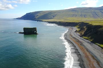
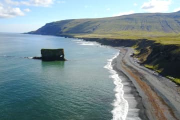
There are many interesting stopping points accessible right off Road No. 917 on either side of Hellisheiði, which are worth taking the time to explore. On the eastern side, there is a hiking trail leading to Landsendi (Lands End) just before the road turns up to Hellisheiði. On the Vopnafjörður side, there are Skjólfjörur and Ljósastapi just inside Böðvarsdalur, and further inland are Virkisvík, Gljúfursárfoss, and Drangsnes.


