Skip to content

Or try searching by Category and/or Location

Top destinations

Rainbow Street in Seyðisfjörður
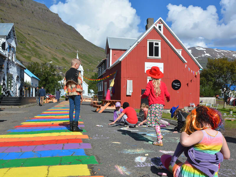
The small town of Seyðisfjörður is famous around Iceland for its colour and creativity. One of its best-known features is the Rainbow Street (referred to as Regnbogagatan in Icelandic) in the heart of town, which can best be described as a beautiful community project. On a sunny day in the summer of 2016 the town's residents got the idea to paint Norðurgata, a cute street in need of some love and restoration. That same night, people in town as well as the town’s employees got together and painted the colours of the rainbow onto the street – unknowingly creating one of the most popular visual landmarks in East Iceland. Year round, guests from all over the world come to visit the Rainbow Street in Seyðisfjörður to snap a "selfie" of themselves on this colourful street, surrounded with old historic houses which the town is also known for. At the end of the street stands the town’s picturesque church, usually referred to as “Bláa kirkjan” or the Blue Church. Ever since then the residents get together regularly each summer to repaint the street, and everyone is welcome to take part.  The Rainbow Street is located right in the town’s center and close by are some great restaurants, the local handcraft market and Blóðberg, a design boutique, all worth checking out. One of Iceland’s best sushi restaurants, Norð-Austur on the second floor of Hotel Aldan, serves sushi from the freshest ingredients available. Café Lára is the perfect stop for some soul food, juicy burgers, and local fish.  Every summer, the Blue Church Summer Concert series takes place and has become one of the major cultural events in East Iceland. It offers a varied program of music where some of the country’s most interesting musicians perform.  Seyðisfjörður is one of the highlights on our Fjord to Fjord travel route. If you are currently travelling around East Iceland or planning your next trip, we highly recommend taking checking out our travel routes for inspiration.
Seyðisfjarðarkirkja
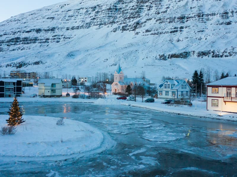
The Church in Seyðisfjörður is one of the most recognisable landmarks in Iceland. With its distinct colour and buildingstyle it has become a popular spot for tourists, especially since the street leading up to it was painted in the colours of the rainbow. The church used to stand at Dvergasteinn farm and in 1882 it was moved to Vestdalseyri. At first the church stood on a hill overlooking Vestdalseyri but in 1894 it was blown over and damaged by a huge storm. The church was rebuilt, this time down on the peninsula and stood there until 1920 when the decision was made to move to its present location in the heart of Seyðisfjörður. In 1989 the the Blue Church was damaged by fire when renovation work was being carried out on the building and a pipe organ that was installed in 1987 was ruined by the flames. Today the Blue Church has a pipe organ of the same type as the one that was lost to the fire. The Church is open for visitors in the summer.
Gufufoss
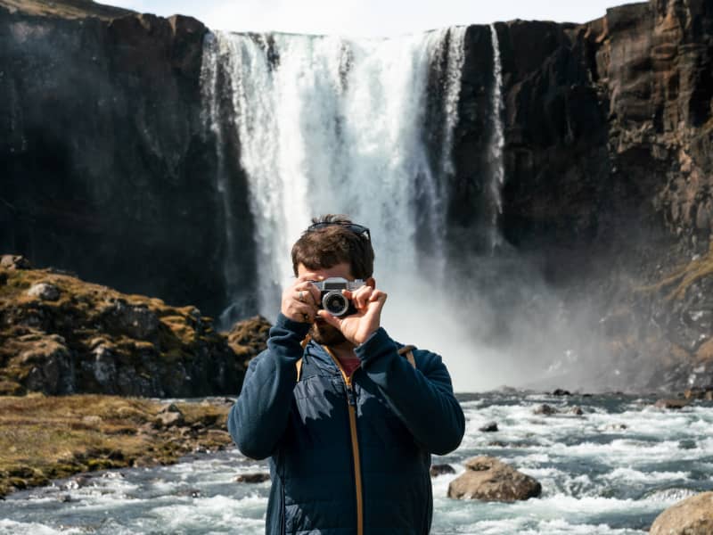
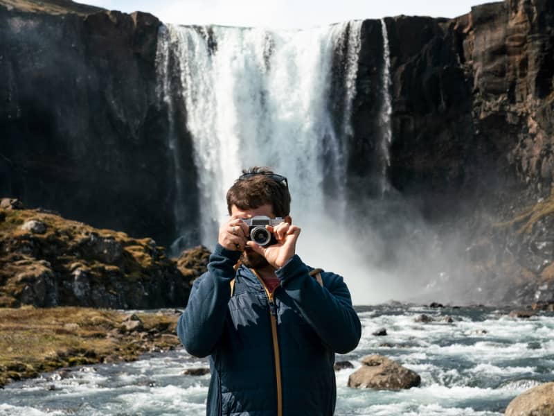
Gufufoss waterfall is a beautiful waterfall in Seyðisfjörður. The name is due to the steam emitted by the waterfall and envelops it in a certain mystery. The road over Fjarðaheiði lies next to the waterfall, and the access to it is very good.
Tvísöngur Sound Sculpure
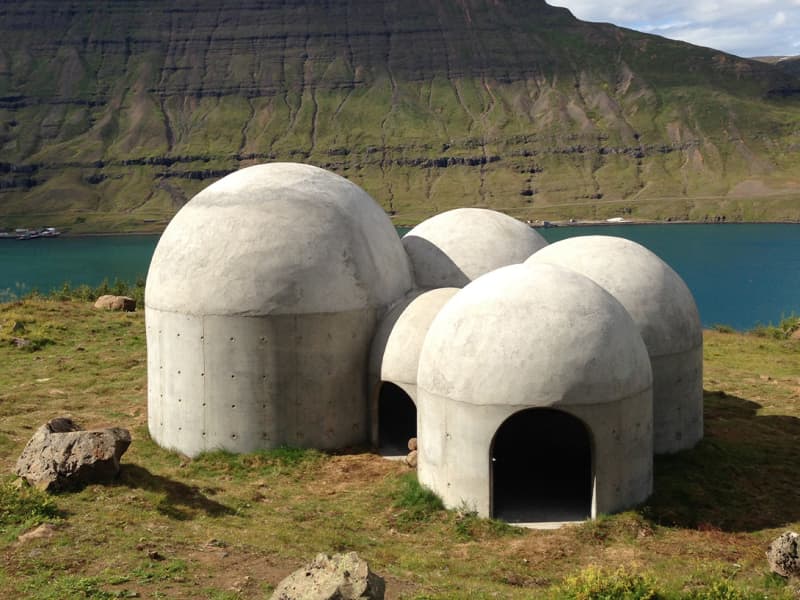
Tvísöngur sculpture, by artist Lukas Kühne, mixes concrete, nature, and sound to create an interactive tribute to Iceland’s unique tradition of five-tone harmony.  The installation piece looks like a grouping of interconnected cement bubbles from afar. Up close the five segments are quite large, ranging from roughly 6 to 12 feet tall and can be entered via rounded arches built into the walls. Once inside the stark industrial domes, visitors will find that they have each been designed to resonate at different harmonies as the wind blowing in off the cliff rushes through the openings. The collective effect is almost as though the wind itself is playing a giant instrument. The five chambers of the piece are meant to recall the Icelandic musical tradition of quintal harmony, with each dome reflecting a tone in the tradition. Juxtaposed with the serene and stark surroundings, it seems as though Iceland itself is creating the music. Tvísöngur is a permanent work and is meant to keep the country’s musical traditions alive, which is not an easy thing to do simply with concrete.
Skálanes
Skálanes nature and heritage centre is situated in a beautifully restored Icelandic farmhouse set in its own nature reserve at the mouth of Seyðisfjörður East- Iceland. Dramatic snow-capped mountains, vast sea cliffs, secluded shoreline and coves, and a vibrant bird colony make Skálanes a place for relaxation, research, contemplation, and a different pace of life.     
Brimnes
Brimnes is an abandoned farm located on the northern side of Seyðisfjörður. It stands beneath Brimnesfjall, which acts as a protective barrier against the north wind. The highest point above the Brimnes farm is Ytra Rjúpnafell, which reaches 771 meters. The upper part of the mountain is characterized by steep and high cliffs, while the lower slopes are green, covered with shrubs and heather. Further out on the peninsula, the land is steep with difficult scree valleys.The coastal vegetation gives the land a distinct appearance. A hike to Brimnes in good weather is unforgettable. The nature is magnificent, and the view to the sea and over the fjord is beautiful. It is also an ideal place to reflect on the history of settlement in this remote location. The best starting point for the hike is Selstaðir, accessible by road No. 951 from Seyðisfjörður. A road was cleared to Brimnes before it was abandoned, but it is no longer driven. The sea route was the main supply route for the residents for most of the time.   Brimnes was a large farm in earlier times. The land was considered excellent for farming, and fishing was practiced. Several small farms were also in the vicinity of Brimnes, including Brimberg near the current lighthouse and Borgarhóll about one kilometer inland from Brimnes. The farm was inhabited until 1961 when the residential house burned down. Significant fishing was conducted in the late 19th century and early 20th century, forming a small community (Brimnessettlement). The Brimnes farm itself was located above Brimnestangi, and just outside it, above Útvogur, an icehouse was built in 1894, one of the first two icehouses in the country. The Brimnes lighthouse was built in 1906 and stands a short distance from the Brimnes farm. The residents of Brimnes engaged in fishing, and numerous visiting boats also fished there in the summer, providing the farmers with income from services. Several buildings related to fishing were constructed during these years, but most were only used in the summer. At the end of the 19th century, up to 40 rowboats operated from the Brimnes settlement in the summer, many from the Faroe Islands. This fishing activity ceased when motorboats became common, as proximity to fishing grounds was no longer as crucial. Remnants of old buildings can still be seen in the area. Near the farm is the place name Klausturskemmutangi, indicating that Brimneswas once owned by Skriðuklaustur monastery in Fljótsdalur.   Brimnes is not only beautiful, peaceful, and prosperous but also a place where nature and the struggle for survival could be harsh. In 1732, an avalanche struck Brimnes farm, killing nine people, while another nine survived. Some sources mention that nine days later, a four-year-old girl was found alive in the ruins. This winter was likely heavy with snow and was subsequently called Brimnes winter. In 1740, a boat carrying, among others, a county governor, was wrecked on a skerry later named Sýslumannsnaggur, located about one km outside Brimnes lighthouse at Sléttanesvogur. Then, on the morning of May 1, 1922, in calm and foggy conditions, the coastal ship Sterling ran aground on the same skerry. All on board, about 50 passengers and 30 crew members, were rescued. They reached land in lifeboats, and the ship's steward served refreshments on a place called Ostabalar nearby. The passengers were allowed to retrieve their belongings from the ship before the Danish coast guard transported them to the harbour at Seyðisfjörður. Goods and various ship items were salvaged from the ship, which was destroyed at the stranding site. There are well-documented records of this stranding, including a list of passengers and crew and an inventory of items salvaged from the ship and sold at auction. This event drew considerable attention since maritime transport was vital for the settlements at that time, with coastal ships transporting people, mail, and goods around the country. Sterling was among the first ships owned by the Icelandic state and was the only coastal ship at that time.   
Brimnesviti
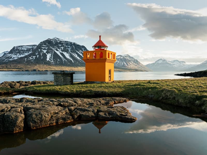
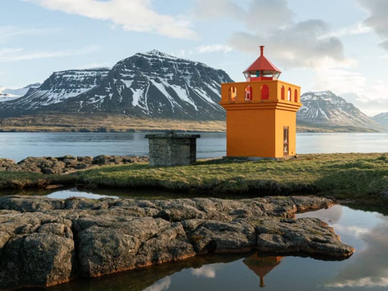
Brimnesviti lighthouse is loated on Brimnes peninsula, which is situated on the north side of Seyðisfjörður´s coastline. A 10 km. drive from the town centre brings guests to Selsstaðir farm. A hiking trail leads from the farm to Brimnes. For centuries, this was one of the bigges fishing centres in Iceland. Traces of old buildings are still visible. 
Stafdalur
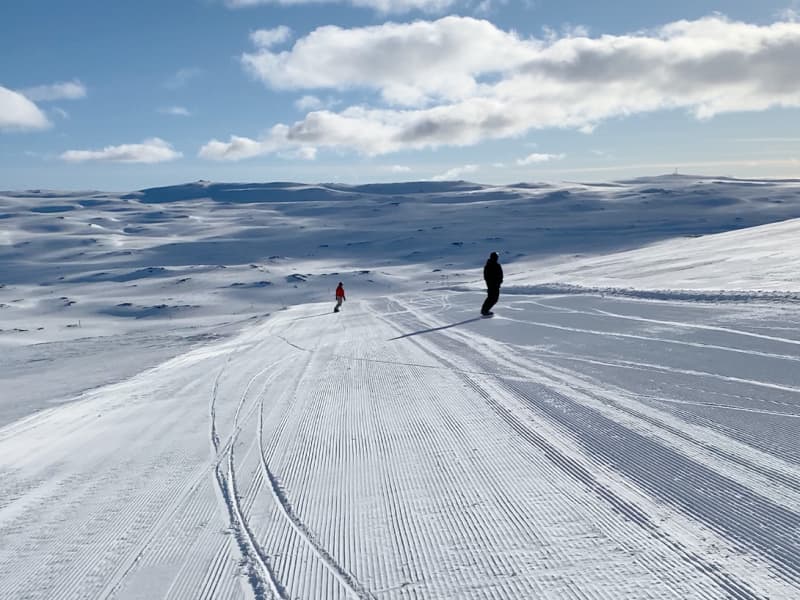
Stafdalur ski resort in Seyðisfjörður is located near road nr 93 between Egilsstaðir and Seyðisfjörður. In the area are 3 skilifts and hills for all kind of skiers. Beginner’s lift is a rope lift 100 meters long and only open on weekends and holidays. Lift nr 1 is a tow lift 900 meters long and has 190 meters vertical drop. Lift nr 2 is a tow lift 700 meters long and has 160 meters vertical drop. Stafdalur has a nordic ski track which is about 5 km long. Ski and snowboard rental is on the area and a hut for all guests.
Vestdalur
A walk to Vestdalur Nature Reserve, Vestdalur lake and the Mountain Lady cave. The route was used to transport mail and trade in the old days between Seyðisfjörður and other towns in East Iceland. In 1880 – 1910 this was one of East Iceland’s most frequently used trails and still presents several pretty, piled-rock constructions, including cairns. After several tiers of glorious waterfalls, you will arrive at a small lake, Vestdalsvatn, which remains frozen most of the year. There you will see Mt Bjólfur to your left. To the right you’ll find the tiny cave where the remains of the Mountain Lady were found in 2004. Around the Mountain Lady cave a group of workers found bones of a 30 year old lady, more than 400 pearls and brooches from the Viking era which have been identified as remains from the year 940.
Vestdalsvatn
A great trail for hiking which involves crossing Vestdalsheiði mountain range, from Hérað to Seyðisfjörður. Vestdalsheiði heath used to be a frequently traveled road. People walked along Gilsá river, across the heath, and into Vestdalur valley. Walk from the sign in Fjarðarheiði (N65°15.577-W14°13.524) and head towards the western part of the mountain Bjólfur. You will see the Lake when you get near the mountain. This is a nice walk in rolling hills. When you get to Vesdalsvatn you can choose between three routes if you don´t want to take the same route back. Down Vestdalur by a staked trail to Seyðisfjörður; down Gilsárdalur valley down towards Gilsárteigur farm (east of Eiðar in Fljótsdalshérað) or go west of Bjólfur mountain down to Stafdalur valley. The cylinder with the visitors’ logbook and a stamp is where Gilsá river runs out from the lake. You will need to cross the river if you choose to walk from Fjarðarheiði. Part of Hiking Treasures in Egilsstaðir Region GPS : N65°17.102-W14°17.887 Powered by Wikiloc
Búðarárfoss
A nice and pleasant hike up to Búðarárfoss waterfall. The hike is easy and gives a great view over the town. Due to a massive landslide in December 2020, the path up to Búðarárfoss waterfall was partially destroyed. Please treat with caution.
Bjólfur and the Snow Avalanche Barriers.
A trail leading to the uppermost mountain slopes (>600 m.) offers a breathtaking view of Seyðisfjörður and the Snow Avalanche Barriers. This 5 km. trail is an F-road and presents a rare opportunity for high-altitude sights for those generally averse to mountain climbing. Furthermore, the spot is ideal for paragliders. The ascent takes about 15-20 minutes from the Fjarðarheiði heath road up to the Snow Avalanche barriers. The trail is open from June - September.
Dvergasteinn
Dvergasteinn (Dwarfs´rock) is situated on the northern shore of Seyðisfjörður, abour 3 km. outside the town. The stone is easily accessible and it is a prominent figure on the shore. According to legend, the rock originated on the other side of the fjord but moved across the sea on its own accord as the local church was movoed from one side of the fjord to the other.  . The legend states that the rock is a site of prayers for the local dwarfs and the idea of staying behind when the Christian church was moved to the other side was simply unacceptable to them.
Austdalur – Skálanes
An enjoyable, easy lowland hike from the parking area by Austdalsá river to Skálanes. Walking further brings one to the natural treasures of Skálanesbjarg bird cliffs. The areas teeming bird life includes nesting eiders, so please show consideration and stay on marked paths. Duration: 1,5 hours / Distance: 4,5 km
Fjallkonustígur hiking trail
A walk to the Vestdalur Nature Reserve in Seyðisfjörður, up to the Vestdalur lake and the cave of "The Mountain Maid". The route once served as the principal communication link between Seyðisfjörður and other regions in East Iceland. Relics of this 19th - 20th c. pillar of transport can still be detected through meticulous road constructions, stone walls, and Cairns. Having passed several tiers of glorious waterfalls, the wanderer reaches a small lake, Vestdalsvatn, which remains frozen most of the year. With majestic Mt. Bjólfur to the left., a tiny cave awaits to the right, the site of one the most important archaeologic discoveries of later times. In 2004 a group of workers unearthed some human bones, later defined as those of lady, around thirtyish - along with more than 400 pearls and some pins dating back to the era of settlement.  The remains are believed to date from the era around 940. These are now conserved at the National Museum. Vestdalseyri / Vestdalur valleyDuration: 3,5 hours / 6 km Period: June - September 
Fjarðarsel Power Plant Museum
A turning point in the history of Icelandic electrification. Fjarðaselsvirkjun in Seyðisfjörður is Iceland´s oldest operational power plant, started on October 18th, 1913. The plant marked a turning point in the history of Icelandic electrification. It was the first power plant that generated alternating current It was the power station of the first municipal electric utility The first high voltage cable in Iceland was laid from this station On the occasion of t he 90th anniversary of the power plant the Iceland State Electricity (RARIK) devided to open the plant to Icelandic and foreign visitors. For this purpose, a historical exhibition was staged in the station house. The first water turbine is still there with its accompanying equipment. For a visit please contact Fjarðasel Museum or the Information Centre. Contact info: Tel: +354 472 1122 / +354 472 1551  Email: info@sfk.is www.fjardasel.is
Fossastígur Hiking Trail
An easy and pleasant walk from the center of Seyðisfjörður town, by a walkway partly gravel, partly grassy through a forested area towards the vale Fjarðarsel where beautiful waterfalls and varied green growth await the wanderer. A visit to the oldest operational power plant in Iceland at Fjarðarsel (1913) is optional, provided that it is arranged beforehand. The plant marked a turning point in the history of Icelandic electrification. For the avid waterfall lover an added walk along the south side of Fjarðará river up to Neðri Stafur rock stratum, (300 m. alt.) is a must. Out of a total of 25 waterfalls, in river Fjarðará some of the most spectacular ones can be seen along the way. At Neðri Stafur rock stratum, the wanderer is presented with an exquisite view over Seyðisfjörður fjord and town, along with a fine selection of berries in late August. The scenic mountains, waterfalls, vegetation, and the history of the town is a wonderful blend that makes this walk unforgettable. Fjarðará River & Fjarðarsel MuseumDuration: 2,5 and 4 hours / 2- 4 km. Period: June - September